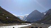
Machoi Peak
Mechoi Peak is a mountain with a peak elevation of 17,694 ft, in Drass region of Ladakh,India. Mechoi Peak is part of the Himalaya Range, and is located between Amarnath cave and Zojila. It lies 105 km north east from Srinagar, 25 km from Sonamarg in the east and 30 km from Drass. It rises from the glacier of its name Mechoi Glacier and is the source of Dras River in Drass, Ladakh. Mechoi Peak rises from the Mechoi glacier and is a pyramid-shaped peak with ice falls and ice fields at its bottom and ridges.
Read article


Top Questions
AI generatedMore questions
Nearby Places
Amarnath Temple
Hindu shrine in Kashmir, India

Zoji La
Himalayan mountain pass in Ladakh, India

Sind River
River in Indian-administered Jammu and Kashmir, tributary of the Jhelum River
Machoi Glacier
Glacier in India
Amarnath Peak
ROUTE OF HOLY CAVE
Zoji-la Tunnel
Road tunnel under the Zoji La pass in the Himalayas
Panchtarni
River valley and hill camp in Jammu and Kashmir, India
Meenamarg
Place in Ladakh, India